

Navionics Naus001l U.S. & Coastal Canada Chart Card - Detailed Marine
Navionics Naus001l U.S. & Coastal Canada Chart Card - Detailed Marine
Price subject to change. Tap below for current.
Couldn't load pickup availability
In this review the Navionics Naus001l chart card is presented as a practical mapping solution for boaters who navigate the U.S. coasts, inland waterways and coastal Canada. The bottom line: this MicroSD chart card puts detailed coastal and inland cartography directly on compatible chartplotters, making route planning and situational awareness easier for recreational sailors and anglers alike. It is most valuable to users who already own a Navionics-compatible chartplotter and need comprehensive regional coverage without subscribing to cloud services.
Key Features
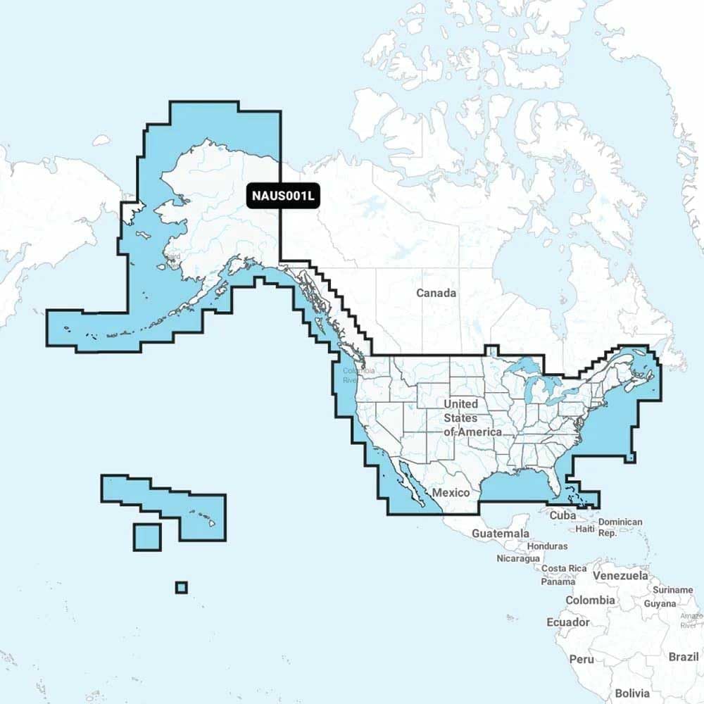
- Region Coverage: Provides extensive coverage of U.S. coasts, lakes, rivers, Alaska and Hawaii, plus coastal British Columbia, the Great Lakes and major Canadian maritime approaches for confident navigation.
- Integrated Mapping: Combines coastal waters, lakes and rivers in one card so users can plan routes that transition between offshore and inland waterways without swapping charts.
- SonarChart HD: Includes SonarChart 1 (0.5 meters) HD bathymetry for improved depth detail useful to anglers and shallow-water navigation.
- Points of Interest and Aids: Displays navigational aids, channels and points of interest to assist with harbor approaches and waypoint selection.
- Compatible Format: Delivered as a MicroSD card for straightforward installation in Navionics-compatible chartplotter systems.
- All-in-One Convenience: Covers nearby territories such as Bermuda, the Bahamas and Baja California, reducing the need for multiple regional cards.
Who It's For
The Navionics Naus001l card is aimed at recreational boaters, fishermen and cruisers who use a Navionics-compatible chartplotter and need broad, reliable coverage across U.S. coastal waters and adjacent Canadian regions. It is especially useful for those who value integrated offshore and inland mapping and benefits anglers who rely on SonarChart HD bathymetry.
Boaters who require real-time subscription services or integrated multi-device cloud syncing may prefer a different Navionics product or plan. Also, if a user only navigates a very small, local area, a single-region card focused on that locale could be a simpler option.
Pros & Cons
Pros
- Comprehensive coverage across U.S. coasts, inland waterways and key Canadian coastal regions for wide-ranging trips.
- SonarChart HD bathymetry adds higher-resolution depth detail helpful for fishing and shallow-water navigation.
- MicroSD format installs directly into compatible chartplotters for offline use without constant connectivity.
Cons
- Requires a Navionics-compatible chartplotter; it is not a standalone navigation device.
- Does not replace cloud-based update services for users who prefer continuous online syncing and streaming features.
Specifications
| Product Type | MicroSD chart card |
| Coverage Area | U.S. coasts, lakes, rivers, Alaska, Hawaii |
| Canada Coverage | Coastal British Columbia, Great Lakes, St. Lawrence Seaway, New Brunswick, Nova Scotia |
| Additional Areas | Bermuda, Bahamas, Baja California, Gulf of California, Johnston Atoll, Palmyra/Kingman Reef |
| Bathymetry | SonarChart 1 (0.5 meters) HD |
| Compatibility | Navionics chartplotter systems that accept MicroSD cards |
Our Verdict
For owners of Navionics-compatible chartplotters who cruise U.S. coastal waters and adjacent Canadian regions, the Naus001l card delivers strong value through wide geographic coverage and high-resolution bathymetry. It is a practical, offline mapping solution that simplifies route planning and improves situational awareness, though users who need live cloud features should consider other Navionics offerings.
Frequently Asked Questions
Will this card work in my chartplotter?
It works in chartplotter systems that accept Navionics MicroSD chart cards; check your device manual for compatibility.
Does it include bathymetry detail?
Yes, the card includes SonarChart 1 (0.5 meters) HD bathymetry for improved depth resolution.
How large an area does it cover?
It covers the entire U.S. coasts and inland waterways plus coastal regions of Canada and nearby territories like Bermuda and the Bahamas.
Editor's Take
The Navionics Naus001l MicroSD chart card is a solid choice for Navionics-compatible chartplotter owners who need broad U.S. and coastal Canada coverage with SonarChart HD bathymetry; it offers strong offline mapping value though it requires a compatible device.

Recently viewed
Recently viewed products will appear here as customers browse the store.